Showing posts with label Hornopirén. Show all posts

Friday, January 13, 2012

Comau fjord


A new route has opened just this season in northern Patagonia and I couldn't resist trying it. I bought a bus ticket and left Puerto Montt for the 10-hour trip by gravel road and by water south to Chaitén. It would be much easier to take the 8-hour boat directly, but this route appealed to me. The bus departed Puerto Montt at 10am. After the first 90 minutes by road along the Gulf of Reloncaví, we arrive at La Arena where our bus joins transport trucks, cars and motorcycles for the 30-minute crossing of the entrance to Reloncaví fjord.


Our boat arrives at the ramp.


Passing Reloncaví fjord, Yates volcano in background. I was on the other (eastern) side of this volcano one week ago in Cochamó.


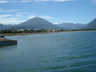
We arrive at the town of Hornopirén at the northern tip of Comau fjord. There is no land road connecting with central Patagonia, but there are three choices of sea travel south.  I chose the new route that passes through this fjord. We leave at 2pm.


Fishing village of Cholgo. Notice the water color indicating a glacial source.


Our boat traveling south on Comau fjord. I was one of 23 passengers on the bus for the 10-hour trip from Puerto Montt to Chaitén. About half of the passengers were young men working on a construction  project, building a new fishing lodge on Yelcho Lake in central Patagonia. The boat holds about 15 vehicles. It's a great day for a suntan(burn).


Entrance to Quintupeo fjord. In 1915 a German warship was evading the English navy and entered this small fjord to make some repairs. It is about 3 miles long and only one half mile wide. The narrow entrance to the fjord allows for a sneaky hideout. When the English were about to discover them, the Germans left a decoy of a large raft with lights and fled the area in their ship. Click here for photos from my 2011 visit to the fjord.


At 4pm we pass by Cahuelmo fjord. We continue traveling south along the Comau. The weather is warm and clear, which does occur in this rainy part of the world.


Passing the northbound boat. We soon arrive at the ramp at Leptepu for the 6-mile land crossing to the next fjord.


Our third and final boat for the day.


Just before docking at Caleta Gonzalo we get a great view of Michimahuida volcano. We are entering the huge southern portion of Pumalín Park that was established by the north American Doug Tomkins. His plan was to purchase huge tracts of land as a nature reserve and then donate it back to the Chilean government. Many Chileans believe he has ulterior motives. Much of the distrust is because his land reaches from the Argentine border to the Pacific Ocean. From here our bus travels the final 58 kilometers to leave us in the town of Chaitén. Click here for more photos of this town destroyed by a volcano in 2008.


Chaitén

Tuesday, January 12, 2010

Volcán Apagado (Extinguished Volcano)


I had the good fortune to meet up with Robert from Patagonia El Cobre in Hornopirén. He and his wife Noemi arrived here about 20 years ago to start a family. They purchased some land near town and began to create a destination for tourists, including a campground and botanical park. They and partner Cristián offer tours by land and kayak in the fjords. It's a bit cold and rainy for me this year, so I chose to explore the land where there is an old volcano with a sandy lava cone and crater. It carries the undistinguished name of "Extinguished Volcano".

A lovely road leads us up into the mountains. This is one of the better sections of the road.

Looking west toward Chiloé

We stop to visit a portion of the dense forest. One of our guides, Patricio, is caretaker of this huge property, more than 50,000 acres. He knows the forest well and can explain much of the flora here.

Logging of the ancient alerce trees was big business in decades and centuries in the past. This remarkable species is very much like the coast redwood of California, with a similar bark. A preferred wood for construction and shingles, the alerce is now protected. Only felled trees can be harvested. This tree is only an adolescent at about 1,500 years of age.

Notro or ciruelillo

This is me in front of a nalca plant. It looks like a giant rhubarb, but the flesh of the stem is sweet and juicy. We decided that it tastes somewhat like a mix of celery and cucumber and is eaten raw.

An ancient Russian truck once used in the logging operations here

A few obstacles in the road must be cleared before we continue. At this altitude (3,000 feet?) the mountains are shrouded in a cold mist with little visibility.

This narrow saddle has perpendicular walls. I try not to look down as we pass over.

We leave the vehicles behind and head up the side of the volcano. The lava is like sand. The air is cool and a little windy. This makes the hike easier than if there were sun.

We conquer the top of the volcano. Here I am with Robert and Patricio, our two excellent hosts and guides.

We have our lunch as we contemplate the crater. The younger folks visited the bottom of the crater. Our descent on the lava sand was like skiing, great fun!

Looking down into the crater.

A small forest on the slope of the volcano

The sky clears considerably in the afternoon as we prepare to leave the volcano. This land was once covered in giant, ancient alerce trees. Many houses along this narrow country are constructed with the wood.

The next couple of days are very rainy, with thunder and hail. I am very content with a book in front of a wood stove in my cabin, but I will have to return here another day to see more sights by boat and horse that I couldn't do this trip. Hornopirén is a town with very friendly people. It is typical of the south of Chile in that one feels completely comfortable. And the food at the Mercado Típico is excellent. I am grateful to the people of Hornopirén for their generous hospitality. Tomorrow I return to Puerto Montt and more adventures.

Monday, January 11, 2010

Quintupeu Fjord


From Llancahue Island I join a group of six passengers to visit the legendary Quintupeu Fjord. There are scattered clouds and sun that allow for some good photos.

Here is Llancahue Island as we begin the journey down the Comau Fjord

Cholgo, a small fishing community with salmon farms

Heading south down the Comau Fjord

Farm along the fjord

In 1915 a German warship was evading the English navy and entered this small fjord to make some repairs. It is about 3 miles long and only one half mile wide. The narrow entrance to the fjord allows for a sneaky hideout. When the English were about to discover them, the Germans left a decoy of a large raft with lights and fled the area in their ship.

The narrow entrance to Quintupeu Fjord, heading west from the Comau


It is just as I expected: emerald green water along a rocky shore with dense, green vegetation of every hue. The walls of the fjord are perpendicular at times, covered with trees and bushes.


One of 5 waterfalls in the fjord

Looking east toward the river that feeds into the fjord.

Saturday, January 9, 2010

Las Termas (hot springs) de Llancahue

This is a land of volcanoes and hot springs up and down the range of Andes mountains. I took advantage of a couple of dry days to visit Llancahue Island, about 50 minutes by boat from Hornopirén. It's a wonderful setting to rest and enjoy the natural hot springs. First, we board the Miska II in Hornopirén.


Soon we see the hotel and hot springs complex as we approach the wharf on Llancahue Island.


The natural hot springs feed into two pools where the tourists can enjoy spectacular views. The food and service were excellent.


I hiked up the mountain behind the hotel, on a steep and muddy trail that enters the dense forest. What a view! This is looking northwest at various islands and the irregular coast of the mainland.


Coming next: A visit to Quintupeu Fjord, where a German warship hid away in 1915 while making some repairs.

Hornopirén

It's a new year and another trip to my favorite destination, the south of Chile. As usual, the trip begins in Puerto Montt, about 700 miles south of Chile's capital, Santiago. After a good rest of two days, I take the bus south to this lovely town of about 4,000 people. I was here last in 2002 when it was about half the size that it is now. Click here to see photos from that trip. The following are photos from 2010.


Black neck swans near the wharf in Hornopirén


Until about 30 years ago the town was connected to the world only by the sea. It was a major supplier of alerce, the ancient trees that were used for construction, somewhat similar to California redwood. The forest is now protected and there is no more cutting of these trees. This woodwork is on alerce that is cut from the remaining trunks in the forest. This beautiful piece is supported by cypress, and has a volcanic rock inserted in the wood.


Two days per week people come to town to sell their goods at the farmers’ market in the mercado típico, a building provided by the town. They offer mussels, clams, merluza (a typical local fish), and some veggies. There are two small restaurants in the same building. I had a delicious shellfish stew with very fresh ingredients.


This is my little cabaña in Hornopirén


It rains a lot in southern Chile. I knew this would be a wet summer. In this storm I may have to get my feet wet to leave the cabin. I have been keeping the wood stove stoked round the clock. Inside I am warm and dry. But I would rather be hiking or exploring the fjord.


Coming next: a visit to the hot springs at Llancahue Island and Quintupeu Fjord.