Here is a fun film of Catalan people taking to the streets. Somehow the full width of the clip does not appear on this page, so CLICK HERE to view the full clip.
Lip dub for the independence of Catalonia and the rest of the Catalan Countries, recorded October the 24th 2010 in the city of Vic. Achieving a total amount of 5.771 participants, the World Records Academy awarded the World Record for being the lip dub with highest participation ever. The initiative was born by a group of Catalans, whose aim is to let the whole world know that Catalonia is a nation, and without its independence it cannot be assured its survival and future. The chosen song was composed by the group "Obrint Pas" and its title is "La Flama".
Saturday, November 13, 2010
Friday, September 17, 2010
Jungle images
 Getting good photos in the Pacaya-Samiria National Reserve was a challenge. By definition a jungle is dense and the light is not always favorable for a basic point-and-shoot camera. Here is our portal into the jungle from our boat. This is where our 6-kilometer transect begins.
 This shows the density of vegetation in the jungle. We were cautioned to not touch logs and trees, as they can harbor biting insects and sharp spines. It was suggested that while walking we focus on the trail where it is easy to trip on a vine or step on a snake. The rule was to not walk when looking up in the canopy.
 This is what I call the "upside down umbrella tree." The roots fan out from the trunk. At the base of each root another cluster of upside down umbrellas begins.
 A "flying buttress tree" spreads wing-like roots at its base.
 These busy leaf-cutter ants were very obvious to the eye, but are difficult to see in a photo. Look for the small, green, irregular shaped pieces of leaf. They are traveling from left to right near the center of the photo. Don't feel bad. We didn't see most of the monkeys our guides spotted along the way. (Click any photo to enlarge.)
 Piraña was a common fish in the Samiria River. It is handled with great caution (and leather gloves).
 Returning down the Marañon River one day we passed by and disturbed a couple thousand cormorants. (Click HERE to see movie)
Thursday, September 16, 2010
Nauta, Peru
 Nauta, a town of about 10,000 people on the Marañon River, is about 65 miles north of Iquitos. It is just upriver from the confluence of the Marañon and Ucayali Rivers, where the Amazon River begins its snaking 2,000-mile flow to the Atlantic.
 River transport is the traditional way to move people and goods. In 2005 a paved road was completed after 20 arduous years of construction. It is the only paved road in the Loreto region, an area covering almost one-third of Peru’s territory. Our group had the morning free to tour Nauta before continuing on to Iquitos by bus. The river level is too low at Iquitos for the Ayapua.
  Rose and I were invited by Rocío to visit her home and family who live not far from where we are docked. Over the past 12 days Rocío single-handedly served three full meals daily to 19 Earthwatch volunteers and seven scientists in the dining room.
  Nauta waterfront
 Vegetables in market
 Yuca (manioc), bananas, pineapple, camu camu
  Rose and Rocío
 This photo says it all for me, representing my experience over the past two weeks:
• Thank you to the people of Loreto,
• Thank you to the Ayapua and her crew for putting up with 19 picky volunteers,
• Hasta la vista to the awesome Marañon River,
• And to the people who live in and around the Pacaya-Samiria National Reserve (background in photo): Thank you for your hospitality and congratulations on your conservation efforts.
Tuesday, September 14, 2010
Community-based wildlife conservation on the Samiria River
 Having just spent two weeks as an Earthwatch volunteer in the Peruvian Amazon, I have the sensation that I just completed an accelerated course in the natural history of the Amazon basin while contributing to the conservation efforts. We were 19 volunteers of diverse nationality, age and experience. For nine days we counted various wildlife species, noting their location and quantity. At the end of each day we entered this information into a database that contains reports of hundreds of counts like ours. Over time, this information shows major trends in wildlife population changes.
 Arthur looks on while Euclides removes the fish net on the Samiria River. Euclides lives in nearby Bolívar and is an expert guide for fishing census. The information we gather reflects the changing practices of local communities. Local people know that a proper balance with nature is the only chance of survival for all.
 Views of Bolívar village from the Samiria River. We had often passed by this village on the way to the day’s activities. It was a pleasure to be invited to visit there on our final day. We were able to report to the village that, thanks to their conservation efforts, some species - such as caiman - were increasing in numbers.
 Village houses are successfully protected from rain with this weaving of palm branches. Our expert guides Alfredo and Euclides invited us into their homes and to meet their families. After 11 or 12 years they will have to build a new house for the family.
 Family garden plots have a mixture of yuca, corn, beans, and bananas. Some fields are dedicated to yuca only.
 Children in the garden, dressed-up. Many children entertained us in the school room with imitations of animal sounds in the forest. After we presented gifts of school materials, the children invited us all to dance to the tunes of the band, consisting of two drums and a quena style flute. The high point of my visit was dancing with Alfredo’s 7-year old daughter in the small school room.
 Nurse Angélica and Roger with village children.
Sunday, September 12, 2010
Pacaya-Samiria National Reserve
 On Monday, August 30, after navigating upriver on the Marañon River in eastern Peru, the 33-meter long Ayapua, with 19 Earthwatch volunteers, several Peruvian biologists, crew and assorted personnel, arrives at the mouth of the Samiria River. The Marañon is one of the major tributaries of the Amazon River. We are just above its confluence with the Ucayali River, where the Amazon proper begins, though it is sometime called the Salimões.
  The water level in this Peruvian area of the upper Amazon basin is at a 40-year low, so we cannot enter the Samiria where we had hoped. We will still be able to conduct field research with small auxiliary boats. We traveled upriver for two days with a flotilla of seven small boats tied to the Ayapua. We will stay on the river for twelve days. Accommodations are very comfortable and the crew is friendly and very helpful. The food is wonderful. We eat lots of river fish and chicken with rice and fried bananas with delicious sauces. It's different every day.
 A crewmember is securing our bow to a tree on the Marañon. From October to December the river level will rise and flood the lowland forest, known as várzea. These trees have high water marks at about 2-3 meters.
  The shore of the Marañon shows signs of low water near our boat. We must navigate around submerged trees and snags every day to get to our study areas. The expert boatmen can do this even in the dark of night when we search for caiman.
 Morning banana delivery at the Ayapua
 Resident tarantula on the Ayapua
 Our job is to help the resident biologists collect and record data about wildlife populations in the Pacaya-Samiria National Reserve. Other volunteer groups have been doing the same throughout the year and more will follow us. Biologist Tula Fang accompanies us while volunteer Sandra records the 58 pink and grey river dolphins we counted this day.
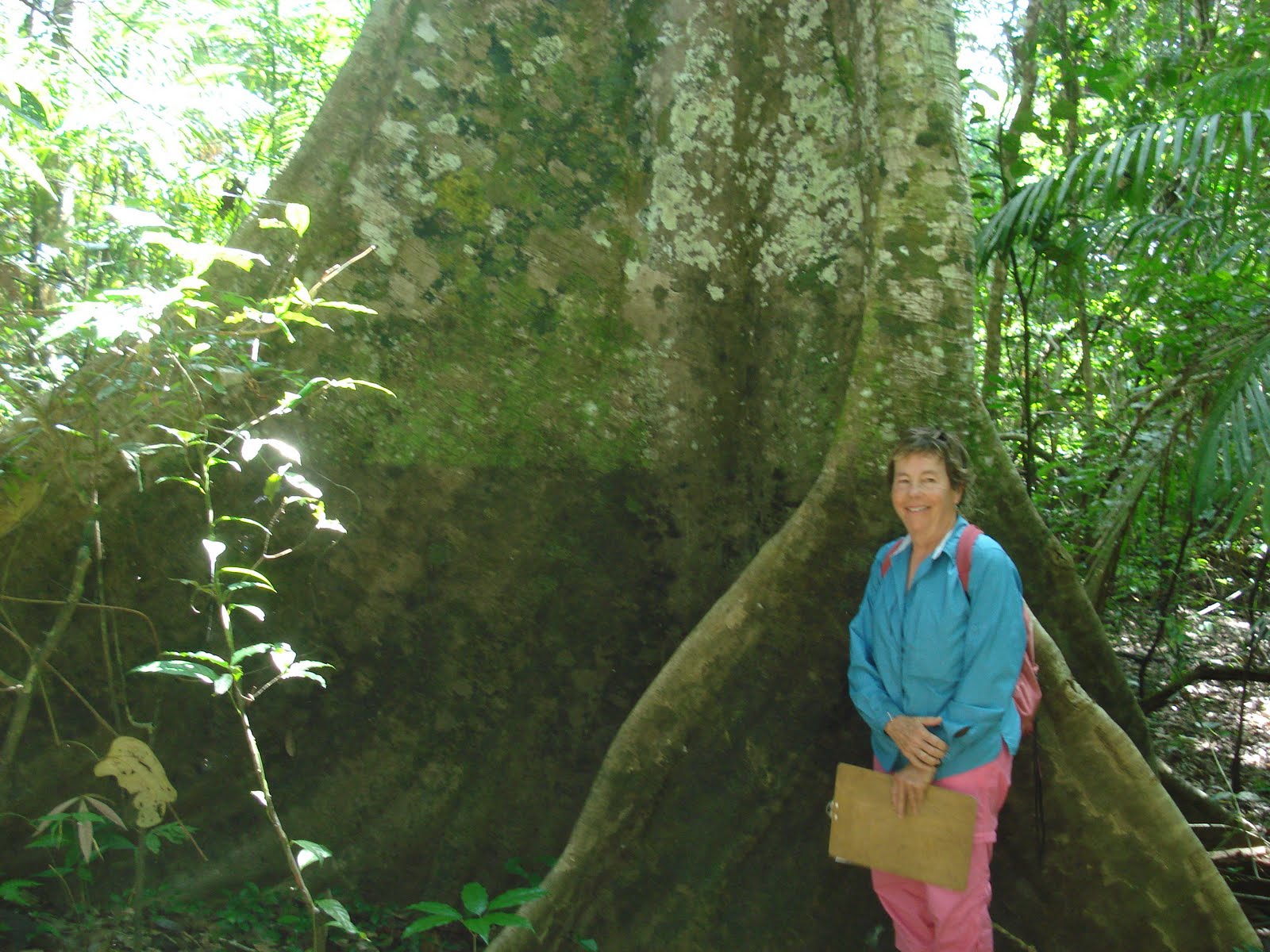 Sandy poses at the base of a “flying buttress” tree. These bizarre roots can occupy a space of 30 feet wide, although the trunk might be only three feet in diameter. This was on the shorter, 4-kilometer transect.
 Few flowers are in bloom in the forest right now, so this was a welcome sight. Of course, the best photo opportunities were lost as they were so fleeting: colorful yellow, orange, blue, or black butterflies that flutter closely by but are gone after 3 or 4 seconds; a flock of 20 brightly colored macaws that flush from a tree top; the graceful and playful movement of dolphins that surface momentarily and grunt only a few feet from the boat; a tamarin monkey gliding through the jungle canopy, almost indistinguishable from the leaves and tree limbs. These are continual sightings throughout the day, and bring great pleasure, if not good photos.
Our guide Alfredo poses with three happy campers, Kim, Tessa and Tom.
 Alfredo and I emerge from the forest after a 6-kilometer trek where he spotted families of different species of monkeys. I later entered the data into the database that reflected 101 animals counted that day on our trek in the jungle. As he watched the treetops, Rose and I watched where we placed our feet so we would not trip on a vine and fall or step on a snake. There were two 3-foot long snakes on the trail.
Saturday, August 28, 2010
Iquitos, Peru
Located on the upper Amazon River, Iquitos was founded by Jesuits in the 1750s to serve the local indigenous people. By the 1870s there were about 1,500 people. Then rubber trees were discovered and the process to create products quickly developed. Within a decade the population increased 16-fold, creating a rubber boom fever that brought entrepeneurs from Europe and the U.S.
By World War 1 the rubber industry collapsed due to the discovery that seeds could be planted systematically on the Malay Peninsula. In Amazonas the trees were scattered throughout the forest. A plantation was much more profitable. Oil was discovered in the 1960s, creating another economic boom. Tourism is also an important industry here.
Many of the buildings in Iquitos date from the rubber era, such as the Casa Morey where I am staying for a couple of nights. By bedroom is huge, about 300-400 square feet, with ceilings about 20 feet high, to better ventilate in hot weather. It has been recently renovated and has excellent air conditioning. My balcony window looks over the waterfront area. The river is so low in this season that people are planting corn in the river bottom.
 This building is similar to my hotel. Pablo is one of the Earthwatch scientists who took some of us on a walking tour of the Belén market this morning.
 Catfish and cilantro at the Belén market
 The mototaxi is the most common way to get around town. They say there are 30,000 in Iquitos.
 Here is a view of the almost dry Amazon River a couple of blocks from my hotel.
 This will be our home for the next two weeks in the jungle. The Ayapua was built in 1906 in Hamburg, Germany. It has been renovated and is air conditioned. The purpose of the trip is to join a group of 20 volunteers from different countries to assist scientists in collecting data for their research in the 5 million-acre Pacaya-Samiria National Reserve. About 95,000 indigenous people live in villages surrounding the reserve. The area teems with wildlife which we will be surveying.
 This will be my last post until my return to Iquitos on September 11. We will have minimal contact with the world until then. Ah, sweet nature!
By World War 1 the rubber industry collapsed due to the discovery that seeds could be planted systematically on the Malay Peninsula. In Amazonas the trees were scattered throughout the forest. A plantation was much more profitable. Oil was discovered in the 1960s, creating another economic boom. Tourism is also an important industry here.
Many of the buildings in Iquitos date from the rubber era, such as the Casa Morey where I am staying for a couple of nights. By bedroom is huge, about 300-400 square feet, with ceilings about 20 feet high, to better ventilate in hot weather. It has been recently renovated and has excellent air conditioning. My balcony window looks over the waterfront area. The river is so low in this season that people are planting corn in the river bottom.
 This building is similar to my hotel. Pablo is one of the Earthwatch scientists who took some of us on a walking tour of the Belén market this morning.
  Catfish and cilantro at the Belén market
 The mototaxi is the most common way to get around town. They say there are 30,000 in Iquitos.
 Here is a view of the almost dry Amazon River a couple of blocks from my hotel.
 This will be our home for the next two weeks in the jungle. The Ayapua was built in 1906 in Hamburg, Germany. It has been renovated and is air conditioned. The purpose of the trip is to join a group of 20 volunteers from different countries to assist scientists in collecting data for their research in the 5 million-acre Pacaya-Samiria National Reserve. About 95,000 indigenous people live in villages surrounding the reserve. The area teems with wildlife which we will be surveying.
 This will be my last post until my return to Iquitos on September 11. We will have minimal contact with the world until then. Ah, sweet nature!
Tuesday, August 24, 2010
Temples of the Sun and the Moon
(Click on images to enlarge)
 The Temple of the Sun (Huaca del Sol) on the south bank of the Moche River near Trujillo, Peru, is a Moche structure about 1,500 years old. It is the largest single pre-Columbian structure in Peru. Although about a third of the original structure has washed away, it is estimated that it once contained about 140 million adobe bricks. It has not yet been excavated.
The nearby Temple of the Moon (Huaca de la Luna) is smaller, and was built in successive stages over 600 years. Each century represents another layer of construction. Excavation began in 1991 at the top level, and only three levels have been uncovered so far. It appears to have been used as a ceremonial and religious center, which includes human sacrifice.

 The top layers have been degraded by looting, rain and wind. But the third layer seems relatively untouched. This shows the remarkable polychrome friezes in their original state. They have not been restored, only cleaned.
 No open spaces were found. After completing the friezes, they were walled in with adobe, which accounts for the preservation of shapes and colors. This is a land of dry desert. But occasional weather, including El Niño years, have taken a toll on the surface layers.


 Below is the view from the highest point on the huaca, looking toward the Huaca del Sol and the Moche Valley. On the desert below are excavations of living quarters of the Moche people. These are very recent, some only begun this year.

 The Temple of the Sun (Huaca del Sol) on the south bank of the Moche River near Trujillo, Peru, is a Moche structure about 1,500 years old. It is the largest single pre-Columbian structure in Peru. Although about a third of the original structure has washed away, it is estimated that it once contained about 140 million adobe bricks. It has not yet been excavated.
 The nearby Temple of the Moon (Huaca de la Luna) is smaller, and was built in successive stages over 600 years. Each century represents another layer of construction. Excavation began in 1991 at the top level, and only three levels have been uncovered so far. It appears to have been used as a ceremonial and religious center, which includes human sacrifice.

 The top layers have been degraded by looting, rain and wind. But the third layer seems relatively untouched. This shows the remarkable polychrome friezes in their original state. They have not been restored, only cleaned.
 No open spaces were found. After completing the friezes, they were walled in with adobe, which accounts for the preservation of shapes and colors. This is a land of dry desert. But occasional weather, including El Niño years, have taken a toll on the surface layers.

 Below is the view from the highest point on the huaca, looking toward the Huaca del Sol and the Moche Valley. On the desert below are excavations of living quarters of the Moche people. These are very recent, some only begun this year.
Subscribe to:
Comments (Atom)