Showing posts with label Patagonia. Show all posts

Sunday, December 24, 2017

Coyhaique, Chile


Panorama of the countryside around Coyhaique, a city of about 70,000 inhabitants in Chilean Patagonia. It was founded in 1929 at the confluence of the Simpson and Coyhaique Rivers. The highway, Carretera Austral, was built in 1980, linking it to the rest of the country. I first visited the town in early 1965, when there were only 4,000 inhabitants. I arrived by ship at the nearby port of Aysén. I was teaching in the Peace Corps further north in Valdivia.


Puerto Aysén, but this is not the ship I arrived on!


Coyhaique in 1965


I met these boys while walking on the road toward Argentina. They offered me a horse to return with them to town, as they doubled up on the two remaining saddles. The first photo above looks down on this road, now paved and lined with many homes and farms, almost 53 years later.


I hired a car and driver/guide to explore the gorgeous country around 6 Lagunas and the Simpson Valley, which I last visited in 2002. This is one of my favorite areas in Chilean Patagonia. Livestock ranching is about the only activity, as the soil is very shallow and doesn't support growing crops.


It's springtime and the lupines are blooming throughout the region.


Farm landscape near Lago Frío


Friday, January 13, 2012

Comau fjord


A new route has opened just this season in northern Patagonia and I couldn't resist trying it. I bought a bus ticket and left Puerto Montt for the 10-hour trip by gravel road and by water south to Chaitén. It would be much easier to take the 8-hour boat directly, but this route appealed to me. The bus departed Puerto Montt at 10am. After the first 90 minutes by road along the Gulf of Reloncaví, we arrive at La Arena where our bus joins transport trucks, cars and motorcycles for the 30-minute crossing of the entrance to Reloncaví fjord.


Our boat arrives at the ramp.


Passing Reloncaví fjord, Yates volcano in background. I was on the other (eastern) side of this volcano one week ago in Cochamó.


We arrive at the town of Hornopirén at the northern tip of Comau fjord. There is no land road connecting with central Patagonia, but there are three choices of sea travel south.  I chose the new route that passes through this fjord. We leave at 2pm.


Fishing village of Cholgo. Notice the water color indicating a glacial source.


Our boat traveling south on Comau fjord. I was one of 23 passengers on the bus for the 10-hour trip from Puerto Montt to Chaitén. About half of the passengers were young men working on a construction  project, building a new fishing lodge on Yelcho Lake in central Patagonia. The boat holds about 15 vehicles. It's a great day for a suntan(burn).


Entrance to Quintupeo fjord. In 1915 a German warship was evading the English navy and entered this small fjord to make some repairs. It is about 3 miles long and only one half mile wide. The narrow entrance to the fjord allows for a sneaky hideout. When the English were about to discover them, the Germans left a decoy of a large raft with lights and fled the area in their ship. Click here for photos from my 2011 visit to the fjord.


At 4pm we pass by Cahuelmo fjord. We continue traveling south along the Comau. The weather is warm and clear, which does occur in this rainy part of the world.


Passing the northbound boat. We soon arrive at the ramp at Leptepu for the 6-mile land crossing to the next fjord.


Our third and final boat for the day.


Just before docking at Caleta Gonzalo we get a great view of Michimahuida volcano. We are entering the huge southern portion of Pumalín Park that was established by the north American Doug Tomkins. His plan was to purchase huge tracts of land as a nature reserve and then donate it back to the Chilean government. Many Chileans believe he has ulterior motives. Much of the distrust is because his land reaches from the Argentine border to the Pacific Ocean. From here our bus travels the final 58 kilometers to leave us in the town of Chaitén. Click here for more photos of this town destroyed by a volcano in 2008.


Chaitén

Wednesday, February 9, 2011

Pumalin Park

Pumalín Park is a unique project of Douglas Tomkins from the United States. In an agreement with the Chilean government, he has purchased a large part of northern Patagonia with the purpose of creating a protected nature reserve. His intention is to eventually return it to the Chileans as a national park. At the time of purchase, several international companies were bidding for the land in order to extract valuable virgin forest resources. It is now a private reserve open to the public. In the northern sector there are a few cabins and a restaurant available to tourists. Throughout the park there are campgrounds that provide running water and covered spaces for tents. Rainfall in Pumalín reaches 12-18 feet in some years. The lush forest contains a huge variety of small and large species of plant growth. I joined a group of tourists for a visit to the park on a rainy day. It lies just a few miles north of Chaitén where I was staying for a few days.

Pumalín Park contains many hiking trails that have been carefully maintained. In a land where rain is almost a daily event, these wooden walkways through swampy land are sturdy and (usually) above water.


There are enough species per square meter to keep a biologist happy for a month.

Young Canelo, sacred tree of the Mapuche people.

Happy hiker

Ancient Alerce tree (fitzroya cupressoides) that resembles the California Redwood, especially the similar bark and their ability to live 3-4,000 years.

At the foot of Chaitén Volcano. Steam is escaping from vents and the caldera. Note the return of life in the trees and the abundant ferns on the ground. The volcano erupted May 2, 2008, after 9,000 years of dormancy.


One of hundreds of waterfalls in the park.


Tiny ferns grow at the base of this cliff, then larger species are found at higher levels. At the top of the cliff are small and large trees.

Click here
to view a slide show with more photos and music

Monday, February 7, 2011

Chaitén lives!

Chaitén is a town in northern Patagonia that was created in the 1940s as a port to ship lumber and livestock north to Puerto Montt, 213 miles north. The rough geography of the area has always prevented a land route to be built. In 2008 it had a population of about 5,000. On May 2 of that year the nearby Chaitén Volcano erupted. It was a small mountain, and geologists figure its last eruption was about 9,000 years ago. On that day in May, it spewed a cloud of ash that over the next weeks and months grew as high as 30 kilometers, almost 20 miles. The cloud followed the natural winds east of the Andes and reached the Atlantic Ocean, and possibly as far as South Africa. Few Chilean towns were affected. Here is a photo found on the Internet shortly after:

The town was evacuated immediately as people left their houses and all their belongings, expecting to return soon. Ships took them north to Puerto Montt and east to the island of Chiloé. The ash fell in the immediate area and filled the nearby river. As torrential rains followed the eruption, the Blanco River filled with ash and could not contain its banks. It overflowed and changed its course, raging through the southern sector of Chaitén, carrying houses and vehicles to the sea. Here is another photo from the Internet which shows the destruction caused by the river:

At first the Chilean government decided to abandon the town and began to build a new one further north. Residents resisted these efforts and were able to convince authorities that it would be safe to return. I visited Chaitén recently, 31 months after the eruption. About 500-600 people have returned and are desperately trying to rebuild their lives. Water is brought in by truck and electricity is provided by individual generators, all which is expensive for people who have been without work for over two years and who have limited funds to rebuild. The following photos show Chaitén in February 2011.


The riverbanks are being reinforced though not all the houses have been removed yet. This was once a street.

And some houses survived the flood. The hotel just reopened two months ago, about 30 months after the eruption. It was relatively undamaged, but the cleanup required a big effort. Some of the back area had to be rebuilt, and Señora Silvia claims that a coat of paint does wonders! Room price is reasonable and each room has a private bathroom. My room had a clear view of the volcano and the steam clouds. Telephone (mobile) 6826 0680.

The volcano today is spewing clouds of steam but seldom ash. Lava flow was never a problem, as the lava has been determined to be the densest found in a volcano. In fact it moved upwards and caused the mountain to grow a little in altitude.

The town square is a green park that invites roaming horses to graze. Since ash had covered the entire town in the flood, any areas free of ash have been cleared, by machine and by hand.

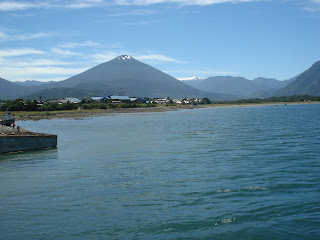
Along the waterfront, looking west toward Corcovado Volcano. I had seen this mountain a couple of weeks ago from the opposite side when I left Chiloé island.

On my last day in Chaitén, I joined Nicolas who runs Chaitur, the local tourist agency, for a drive south to Villa Santa Lucía. It was one of those rare days in Patagonia when the sky is clear and the temperature unusually warm. I had traveled this 46-mile segment of the Carretera Austral more than once, but never on a clear day. This was my first glimpse of the mountains.

Michimahuida Volcano


Yelcho Glaciar, River and Lake

Click here to view a video slide show with more photos