Showing posts with label Wari. Show all posts

Tuesday, August 13, 2013

Cumbe Mayo and Bosque de Piedras


The Bosque de Piedras (Stone Forest) is an area about 12 miles from Cajamarca, Peru, where there is a proliferation of stone outcropping. It is perched on the Andes at a point where water drains to the Atlantic and to the Pacific, a continental divide. There is evidence that people have used this natural phenomenon for religious purposes for milenia.


Ancient culture flourished in the Cajamarca region for thousands of years. It became an administrative center of Wari culture, which flourished about 500-1000 AD. This was a period of empire building in the south-central Andes and coastal area of modern-day Peru. Extensive road building and terrace agriculture were two major features of the Wari. Centuries later, the Inca expanded this empire and the network of roads, extending from Quito, Ecuador to central Chile.


The stone forest comprises many unusual natural formations. Some niches were used for ceremonial purposes, as evidenced by ancient carvings in the stone. My tour group is about to pass through a narrow passageway through the rock. It is completely dark inside, with a curve and uneven terrain. Fortunately it is a rather short passage, though spooky.


We successfully pass through to the other side of the forest.


This young girl is spinning wool, probably alpaca, posing for tips from tourists. The large hat is worn by indigenous women, though usually not by girls. I was told that the hat is a measure of wheat in the village market. Bright colors are typical in the dress of women in the Andes mountains.


These strange natural rock formations suggest figures of animals, though I don't see any in this photo.


Cumbe Mayo is located about 12 miles (19 km) southwest of the city of Cajamarca, at an elevation of approximately 11,000 feet (3,300 meters). The location is best known for the ruins of a Pre-Incan aqueduct stretching approximately five miles in length. The aqueduct collected water from the Atlantic watershed and redirected it on its way to the Pacific Ocean. It is thought to have been constructed around 1500 B.C. and was once thought to be the oldest existing man-made structure in South America. The name Cumbe Mayo may be derived from a Quechua phrase, kumpi mayu, meaning “well-made water channel,” or humpi mayo, meaning “thin river.” (courtesy Wikipedia)


This zig-zag in the course of the aqueduct had a specific purpose, causing a whirlpool which would affect the speed of the water. In some places the channel narrows which causes the water to run faster and thus rise in elevation. And this channel ran for five miles!


There are a number of petroglyphs on the aqueduct and surrounding caverns.


The weather here in the austral winter is dry and clear, with cool evenings and warm days. The 4-hour tour was led by Miguel, an expert in ancient history of the area, and we were a group of about 20 tourists.


Thursday, August 8, 2013

Ventanillas de Otuzco

About five miles northeast of Cajamarca is the village of Otuzco, set in a fertile, green valley.


The people who lived in this region of the northern highlands of Peru for milenia are referred to historically as the Cajamarca culture. The Wari conquered this area about two thousand years ago and made Cajamarca one of their many administrative centers, connecting by road with the Wari capital in Ayacucho. The Inca conquered the region in 1460 AD, connecting their capital in Cuzco with Quito, Ecuador. The Spanish, led by Francisco Pizarro, took over in 1540.


The Ventanillas (“little windows”) of Otuzco is a large stone outcropping that was used for burials. This huge necropolis consists of 337 graves sculpted in the rock, superimposed one on top of the other and protected against the rain with narrow channels.


The niches have been looted long ago. It seems that the elite were first interred in the ground. The body was then exhumed, and the cleaned bones were placed in a niche, which was then sealed.


Most niches appear rather shallow, with room for the bones only. Others are reported to contain galleries of graves that extend 33 feet into the rock. A few (as in the center of the photo) were not completed, and are shallow depressions in the rock.


The reddish color is the lichens growing on the rock.


This ragtag group of boys entertained us with a typical Andean folksong. A short video is available here.


This is typical construction in the area. The adobe bricks are made from the local soil. The layers are separated by stones, allowing air to flow.


After visiting the Ventanillas, our tour group stopped at the Jardín de Hortensias (hydrangea gardens) to see the flower gardens, sample some local food and drink, and to buy handicrafts. Click here to see photos of the gardens with text in Spanish.


Food is available for purchase, such as fried pork (chicharrones) and corn tamales (humitas)


Cuy (guinea pig in English) was domesticated thousands of years ago in the Andes mountains in the region of Ecuador, Bolivia and Peru. They are commonly found in households as pets and as a food source. They are herbivores, living off kitchen scraps, and are part of the Andean diet. They contain high amounts of omega 3, low in fat, and high in proteins.


Fried cuy (courtesy Wikipedia)

Tuesday, September 25, 2012

Huaca Pucllana, Lima, Peru


A major archeological site of the Lima culture (200-700 CE) is found in the Miraflores district of Lima, the capital of Peru. As in many sites throughout Peru, this one contains a huaca, or pyrimid structure used for ceremonial purposes. The above photo shows a small portion of the structure made of adobe bricks and clay. The Lima culture was succeeded by the Wari (ca. 500-1000). My visit was on August 4, 2012.


The huaca covers a large area of several acres, much of which has been destroyed by the urbanization of Lima. Studies of the site began in 1967, but by 1981 it still suffered from neglect. A street runs through an ancient section, but what remains is now a protected zone, as scientists continue to study and map the structure. Some areas have been restored, but much of the original construction remains.


Coastal Peru is affected by periodic violent earthquakes, so the inhabitants learned to build with adobe bricks in a way that would resist the movements. Instead of laying bricks horizontally, they placed them in a vertical position, in triangular groups.


Plaza de los Ancestros, where the ancestors are buried


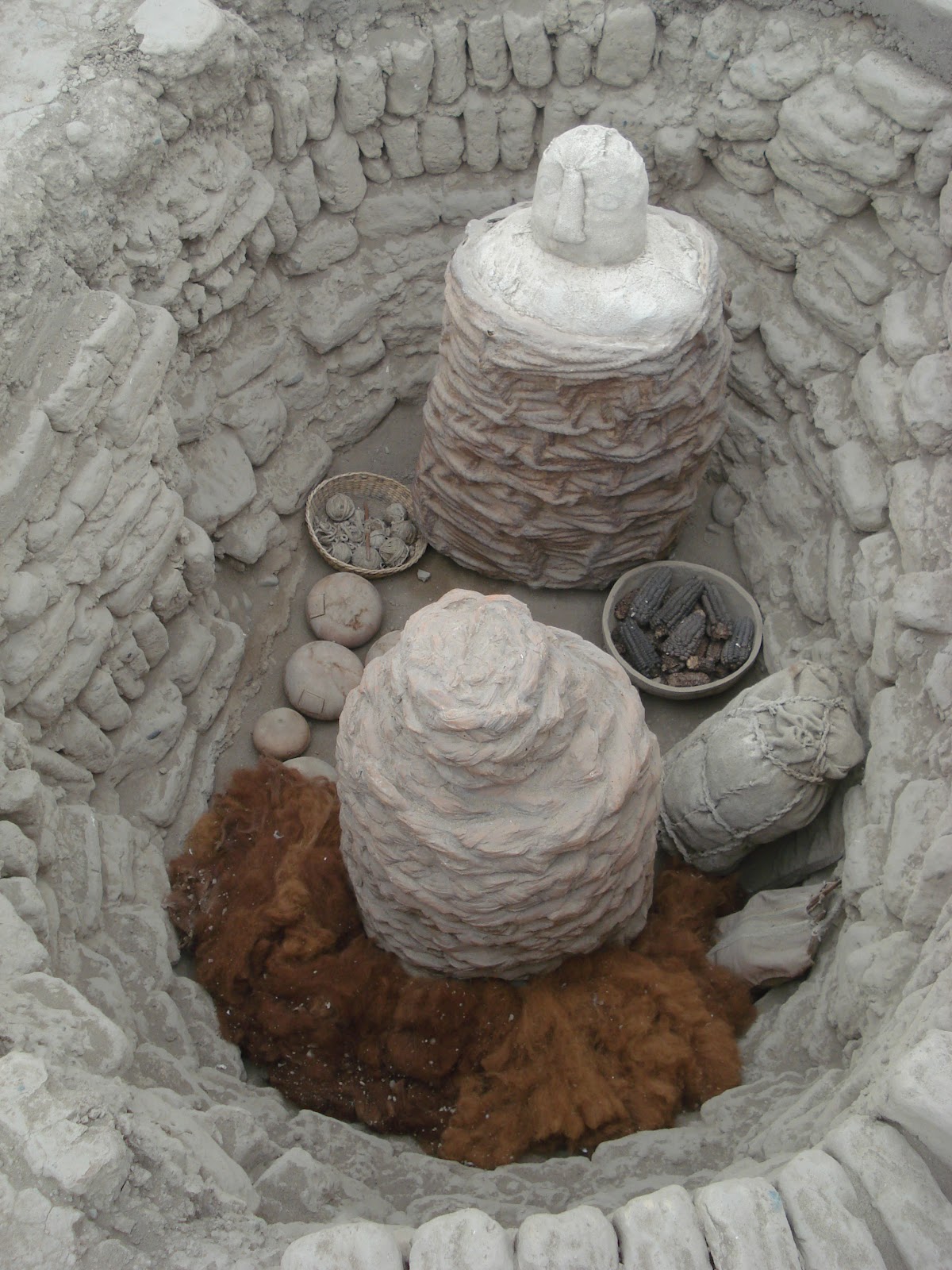
This (reconstructed) burial tomb contains the remains of a man and a woman and a child. A false head sits atop the clay sarcophogus. The woman is identified by the wool tufts that she will need in the afterlife for her weaving. A basket of purple corn will provide the corn to make chicha, a favorite beverage.


A friendly Peruvian hairless dog, found at most historical sites


A typical kitchen garden and livestock are kept at the site to show visitors the common food items in the ancient diet


Llamas and alpacas provide wool and meat.


Cuy (guinea pigs) are a common source of protein in Peru

Internet site in Spanish:
http://www.mirafloresperu.com/huacapucllana/index.htm