Tuesday, September 25, 2012

Huaca Pucllana, Lima, Peru


A major archeological site of the Lima culture (200-700 CE) is found in the Miraflores district of Lima, the capital of Peru. As in many sites throughout Peru, this one contains a huaca, or pyrimid structure used for ceremonial purposes. The above photo shows a small portion of the structure made of adobe bricks and clay. The Lima culture was succeeded by the Wari (ca. 500-1000). My visit was on August 4, 2012.


The huaca covers a large area of several acres, much of which has been destroyed by the urbanization of Lima. Studies of the site began in 1967, but by 1981 it still suffered from neglect. A street runs through an ancient section, but what remains is now a protected zone, as scientists continue to study and map the structure. Some areas have been restored, but much of the original construction remains.


Coastal Peru is affected by periodic violent earthquakes, so the inhabitants learned to build with adobe bricks in a way that would resist the movements. Instead of laying bricks horizontally, they placed them in a vertical position, in triangular groups.


Plaza de los Ancestros, where the ancestors are buried
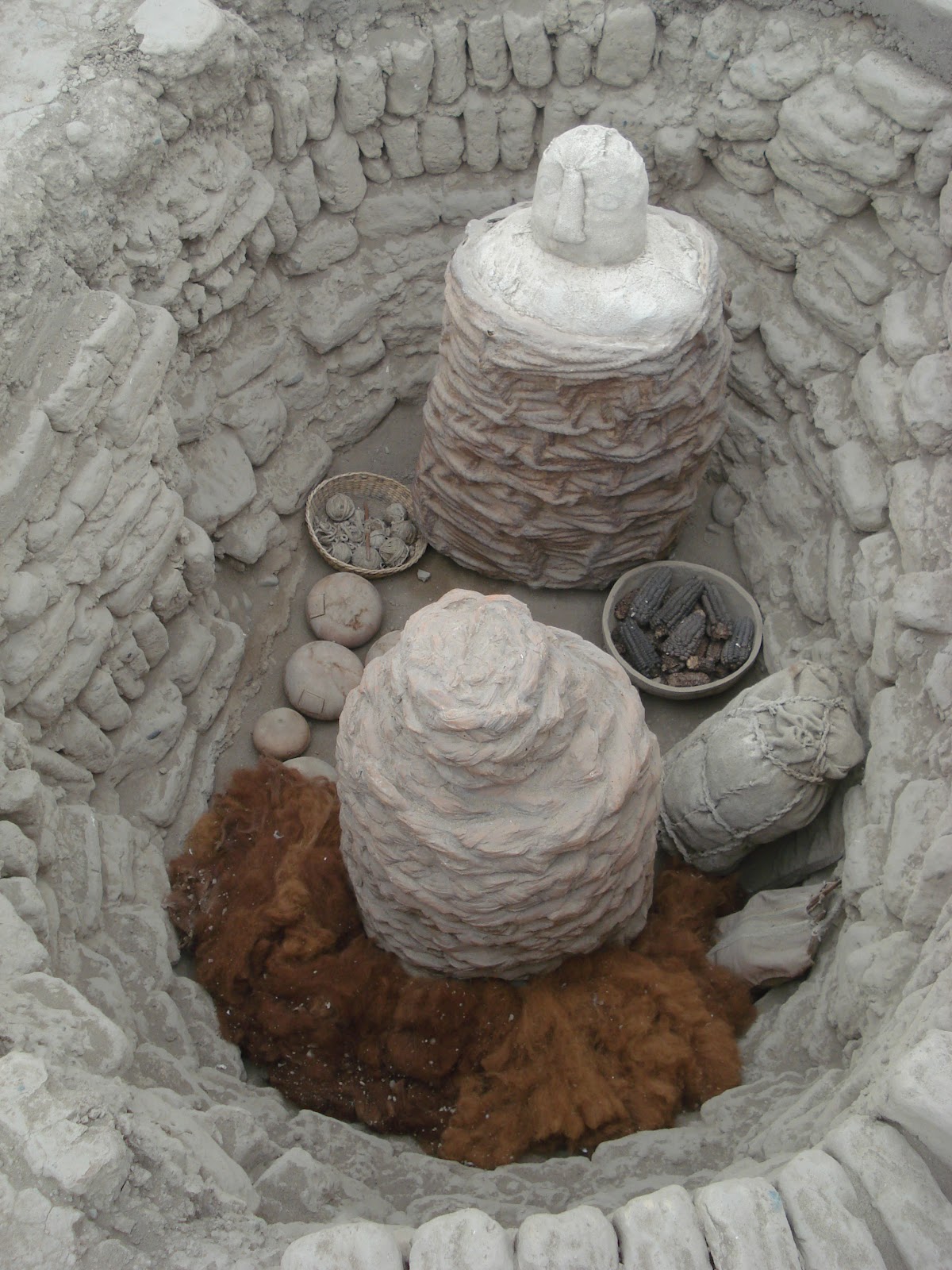

This (reconstructed) burial tomb contains the remains of a man and a woman and a child. A false head sits atop the clay sarcophogus. The woman is identified by the wool tufts that she will need in the afterlife for her weaving. A basket of purple corn will provide the corn to make chicha, a favorite beverage.


A friendly Peruvian hairless dog, found at most historical sites


A typical kitchen garden and livestock are kept at the site to show visitors the common food items in the ancient diet


Llamas and alpacas provide wool and meat.


Cuy (guinea pigs) are a common source of protein in Peru

Internet site in Spanish:
http://www.mirafloresperu.com/huacapucllana/index.htm

Friday, September 14, 2012

Castro, Chiloé, photo exhibit Aug 2012


An exhibit of color photographs from 1965,
taken by a casual tourist on the big island of Chiloé, Aysén and Magallanes. 

Color film in that era was scarce and expensive. I had the honor of a faculty position at the Music Conservatory of the Austral University in Valdivia, Chile. Some friends invited me on a trip to the island of Chiloé in January 1965. The journey included travel in a small Cessna airplane from Puerto Montt to Castro, Chiloé. While on the island, I visited Castro, Ancud, Achao, and Chonchi. From there, a small cargo ship delivered me to Puerto Aysén. The only exit from Coyhaique was a DC-3 which flew south to Punta Arenas, on the Straits of Magellan. From there I returned north to Puerto Montt for a visit to the fish market at Angelmó, before returning to my home in Valdivia.

Typical transport of the time

This project of showing 30 photos from the collection was supported by the I. Municipalidad de Castro and Banco del Estado. The photos were prepared and mounted by Javier Areneda. I am indebted to  Felipe Montiel, historian, author, and Director of the Regional Museum of Castro, for his persistence in mounting this project. Many thanks to Juan Carlos Pacheco in coordinating the exhibit.

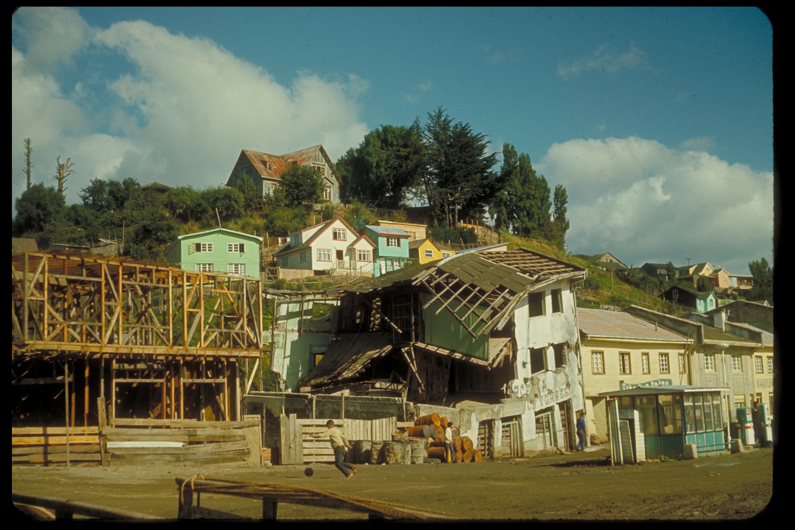
1960 earthquake damage in Castro

The opening of a new photo exhibit was announced for Friday at 7:00pm. This was my first and probably only event of the kind, so I made the effort to travel to southern Chile in the cold of winter, August 2012. I had no idea what to expect of this event. So, like a typical gringo that I am, I arrived at the appointed time. Social events in Chile typically begin well after the announced hour. To my great surprise, I was the last to arrive, and was welcomed by local and regional government officials, and uniformed representatives of the Carabineros and the Navy. Sergio Colivoro, the leading accordionist of Chiloé, was invited to  perform for the crowd, and dedicated his last song to me. I did three press and radio interviews and found my picture in the Sunday paper of Chiloé, La Estrella. About 100 people attended the opening.

Sergio Colivoro


Recording an interview for the local radio

Children in Achao 1965

The complete collection of 30 photos is available on YouTube.

Click here to go to slide show.

Tuesday, March 27, 2012

The Alhambra, Granada, Spain


The Alhambra from Mirador San Nicolás, near sunset. The 12-acre complex of buildings was constructed beginning in the 13th century, first by Moorish kings, and in the 15th to 16th centuries by the Catholic monarchy. Note the snow-covered Sierra Nevada mountains in the background. That is the water supply for the entire area.


View from the opposite direction of the first photo, the Albaicín neighborhood as seen  from El Alhambra


The Generalife, the sultan’s summer palace where the royals would go on a hot summer day, an easy stroll from the Alhambra.


The Moors developed a remarkable system for water distribution, which they learned from the Romans. Water was diverted from the Sierra Nevada. It coursed through the Alhambra and then into the Darro river just below. Fountains are found throughout, accompanied by the gentle sound of running water.


View of the Alhambra from the gardens of the Generalife.


Bridge across the moat connecting the Alhambra with the Generalife.


The Alcazar, the fortified area of the Alhambra, enclosing the royal palaces.


Puerto de Vino, the entrance to the Alcazar.


The reflecting pool


Islam forbids the representation of people or animals, so the elaborate decoration of walls contains geometric tiles and inscriptions from the Koran.


Tom, María and Roger at the end of the tour, taking us almost two miles around the 12 acres of the Alhambra.


Statue of Washington Irving, who wrote Tales of the Alhambra in 1829 during his four-month stay here. His efforts led to a greater interest in the preservation of this remarkable monument to Moorish architecture.

Coming soon: photos of Granada and other sites in Andalucía