Monday, January 30, 2012

Cucao, Chiloé


 The next stop on my tour of Chiloé island is the small village of Cucao, about 25 miles north of Quellón and on the west coast of the island. This view is from my room at Hostal Palafito Cucao, situated on the bank the Cucao river and looking east at Cucao Lake.


There is excellent cazuela de vacuno (beef and vegetable soup) in the green house across the Cucao River.


The Cucao National Park is a favorite destination for many Chilean and foreign visitors. Many come for the day, and others come to camp or stay in one of the many lodgings available. The above view is the national park trail to the dunes and beach.


The lookout over dunes and beach. This white sand beach is 15 miles long! Charles Darwin stopped by here in the Beagle in 1835. From his journal of January 24:

            “The district of Cucao is the only inhabited part on the whole West coast of Chiloé. It contains about thirty or forty Indians, who are scattered along four or five miles of the shore, and without a single Spanish resident. — They are very much secluded from the rest of Chiloé & have scarcely any sort of commerce, excepting sometimes a little oil which they get from seal blubber. They are pretty well dressed in clothes of their own manufacture, & they have plenty to eat.”


Dunes and beach looking north to Huentemó


Parrots feeding in a tree in the national park.


A short walk inland takes visitors to the tepual, a swampy area covered mostly in tepu trees (tepualia stipularia). A sturdy boardwalk winds through the tepual and many signs help to explain this unique ecosystem.


The tepual


View of Cucao Lake from a lookout in the tepual.


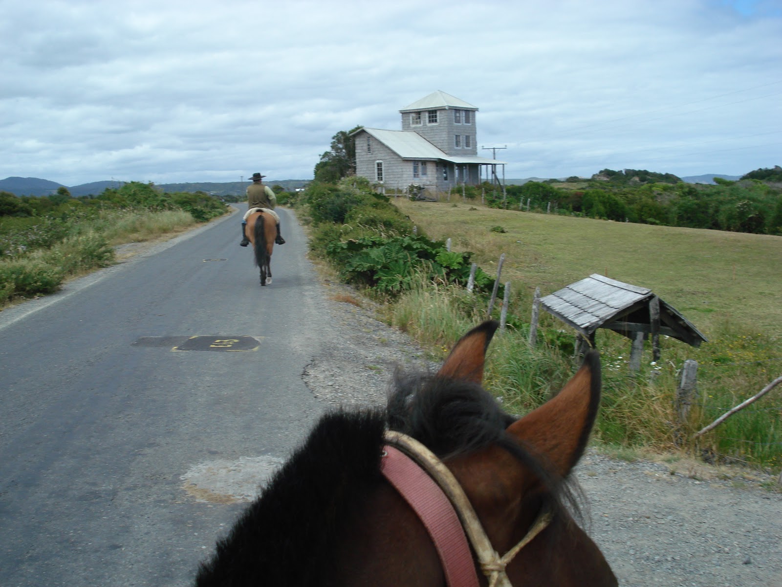
On another day, Patricio (Pato) is my guide to the dunes. I always prefer four sturdy legs under me, rather then my questionable two.

Pato takes me into the hills above the beach and park. This is looking south toward Pirulil.


View of Lake Huelde


Our return to Cucao after about three hours on the trail. In another hour I will take a bus north to the town of Castro, capital of Chiloé.

Monday, January 23, 2012

Tantauco Park


Created in 2005, Tantauco Park comprises almost 300,000 acres (456 square miles) on the southern tip of Chiloé Island. The island itself is 118miles long from north to south and averages 34-40 miles in width. So the park is a large presence here. It is a popular ecotourism destination, containing two campgrounds and 93 miles of hiking trails. Rainfall averages 98 inches per year.


The land was purchased by Sebastián Piñera, current president of Chile, as a private nature preserve open to the public. There is some controversy regarding the park, which is considered to be on ancestral lands of the indigenous Huilliche (southern Mapuche) people.

The northern sector of the park is accessible by road from Quellón at the southern terminus of the Panamerican Highway, where trekkers enter to hike the 5-day trail south to the park headquarters on the very tip of the island. This area is accessible only by sea via a challenging 3-hour crossing by speedboat. The headquarters is located in the fishing village Inío (pop. 140), with a considerable infrastructure. The new park has an interesting role in the community. It provides many needed services while the local people provide labor for the park and its visitors. A veterinary service is provided for pets in the village. As a concern for native wildlife, all female dogs have been spayed and most males neutered.


Administration building


Medical clinic


School


There are no cars or roads here, just fishing boats and oxen. The happy expression on these faces is typical of this unique place. Everyone here seems happy, due to the availability of work and natural resources.


The park has built wooden sidewalks around the headquarters to protect the fragile ecosystem.


The park guesthouse. My room is on the second floor. A kitchen and sitting area are on the first floor.


The only tourists this week were Veronica, Phil and me. Señora Enofra (front, right) served us breakfast and maintains the guesthouse, a lovely facility with comfy beds.


This greenhouse provides delicious organic vegetables to visitors and park staff.


Surrounding the greenhouse are more vegetables, herbs and flowers. I stop by each day after dinner to choose the herbs I will have in my tea.


Seedlings are cultivated for a large reforestation project. There are areas nearby where trees were inundated and drowned by the 1960 earthquake. That quake is the largest ever recorded and struck near Valdivia, further north. It registered 9.5 on the Richter scale.


These trees will grow to hundreds of feet tall.


Henry is our guide for a 4-hour hike in the mountains above Inío.


This lizard takes on the colors of the ferns.


Sturdy stairs and bridges mark the forest trail.


This cluster of caterpillars on a tree trunk are interesting to watch but not safe to touch.


The forest around Inío has many species of trees and shrubs.


Alas, it's time to leave this enchanting place.

Sunday, January 22, 2012

Caleta Inío


 The fishing village Inío (pop. 140) sits in a protected cove at the very southern tip of Chiloé Island. People began living here around 1980, drawn by the abundant stocks of shellfish and pelillo, a seaweed useful for industrial purposes. It is a common ingredient in shampoo and ice cream.


Pelillo drying on the beach


Lunch. Sea urchins, clams, cholgas (large mussels) and locos (similar to abalone). These were taken from the sea within the hour

There is no road to the village, and the only access is by sea from the town of Quellón. The regular fishing boats take about six hours each way. There is now a faster boat that makes the trip in under three hours, but can carry a few passengers and some supplies. My face was not so happy when we got out to the open sea, with large swells coming in from the Pacific Ocean.


La Puntilla. This sand spit protects the village across the bay, but is in a direct line for tidal waves. The 2011 tsunami from Japan damaged much of the area. In February 2012 there is a plan to move all the houses across the bay. This will be done in traditional chilote style. The houses will be prepared for transport, and then yokes of oxen will drag them to the water where they will be floated on logs across the bay. There, oxen (or possibly heavy machinery now in use to make a landing strip) will pull the houses to dry land for placement on newly cleared lots. The traditional event found throughout Chiloé is called a minga, and will be an occasion for abundant feasts and partying. (There are some mingas available to view on YouTube.)


 The entire west coast of Chiloé has sand beaches. The east coast, however, has no beaches, and the forest often comes right to the water’s edge.


Several caves have been formed along the coast, and many were used by the indigenous Chono people as a refuge from the weather, where they could stay relatively dry and make fire. Here our guide Fernando poses at the entrance to the largest cave in the area. Red lichen grows on the face of the rock, beginning the process of creating new earth.


Inío, looking southwest toward the Pacific Ocean. Small islands lay offshore.

Tuesday, January 17, 2012

Quellón


The town of Quellón is in the distance, population about 14,000. I came to this swimming area for lunch today, at Punta Lapa, a point of land connected to the town. Great salmon!


My hotel overlooks the waterfront. Punta Lapa is in the background.


The low tide gives these boat owners a chance to make repairs. Some people are building boats nearby. The fishing industry is huge here, and unemployment is almost unknown. Salmon farms and shellfish extraction provide abundant work.


Sacks of clams are a daily catch to be loaded on to refrigerated trucks for shipment north.


These workers are loading seaweed to be exported for industrial use.


Chaitén


This shows about one third of the recovering town of Chaitén, destroyed by a nearby volcano. I arrived at the lookout about 15 minutes too late, as clouds are forming around the distant Corcovado Volcano. What looks like low tide to the right of this picture is ash deposit from the 2008 eruption of the Chaitén Volcano. You can see a little of the edge of the sea, about a quarter mile off the old waterfront. Ash spewed 20 kilometers up in the air and arrived at the Atlantic Ocean, several hundred miles to the east. 


View of the volcano, about four miles east of town, still spewing steam on some days.


The town still has a long way to full recovery. Many condemned houses are still standing. The volcano is in the background.


¡¡Llegó el Gas!! Gas has arrived. This store sells the propane that people need for heating water and for cooking.


Arrival of the Don Baldo from Puerto Montt. Before the eruption, the sea arrived to about where the picture is taken. The ash permanently covers the waterfront.


Preparing to offload large trucks, heavy equipment, cars and passengers. Here is a good view of Corcovado Volcano.


Monday morning at the landing, waiting for the Don Baldo. Colors are vivid at 9:00 am. I waited with others for four hours before it unloaded and uploaded.


We are underway, finally. The town of Chaitén is in the background, and further on, Corcovado Volcano. What looks like beach is accumulated ash from the 2008 eruption.


Chaitén is in a gorgeous setting, nestled under the mountains. After four hours sailing we arrived in Quellón, at the southern terminus of the Panamerican Highway, on the island of Chiloé.


Approaching Quellón on the Chaiguao Channel.